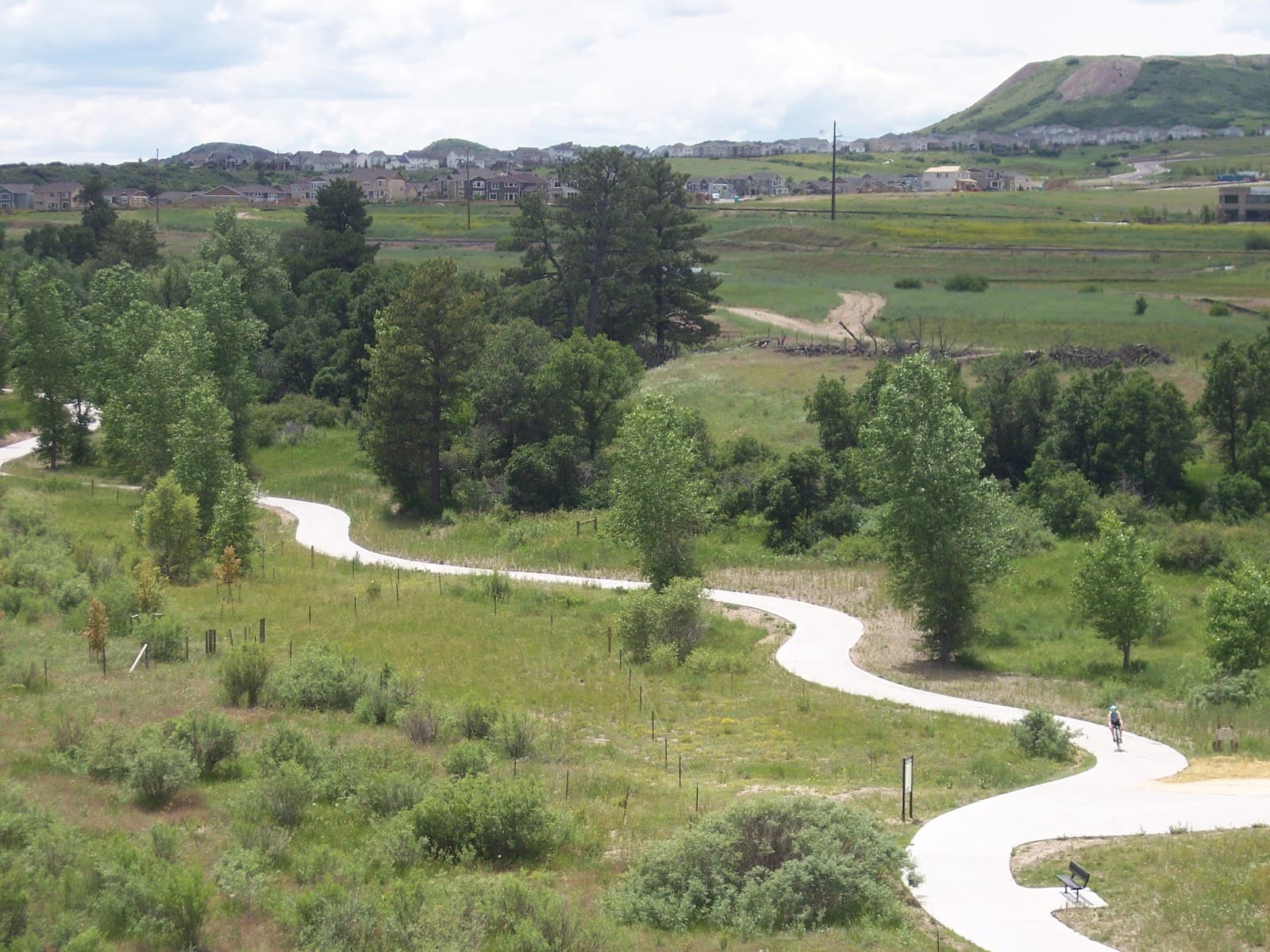
Ridgeline Trail

Castle Rock's flagship trail system: about 13.5 miles of interconnected color-coded loops on 367 acres, with a 9.5-mile main loop, oak and grassland, ridgeline views, and a pedestrian overpass to Philip S. Miller Park.
Why it's here
Ridgeline Open Space is the Town of Castle Rock trail system that most locals default to, and for good reason. It is a 367-acre property with roughly 13.5 miles of trail counting connectors and feeders, organized as four interconnected, color-coded loops, with the Stewart Trail forming a main loop of about 9.5 miles marked every half mile. The Coachline Road trailhead is the main access, with a second entry from Bison Park, and portable restrooms at the trailhead.
The reason it works for so many different users is the loop structure. You can do a short grassland stroll or a half-day ridgeline circuit on the same property by choosing which color loops to link, and the half-mile mileage markers make it easy to turn around on a known distance. The terrain is open grassland and dense Gambel oak with real Front Range views from the ridgelines, and it connects to Philip S. Miller Park via a pedestrian overpass at Wolfensberger Road, which means you can chain Ridgeline into the amphitheater-and-Challenge-Hill side of town on foot.
Dogs are allowed and must be leashed, and that rule is worth respecting here because this is a heavily used multi-use system. It is a popular easy-to-intermediate mountain bike network as well as a hiking and running trail, so expect to share the singletrack and step aside for bikes on blind corners. This is rattlesnake habitat like most of the Front Range foothills; keep dogs close and watch the trail edges in warm months.
The one number we will not hard-state is total elevation gain, because the managing agency does not publish it and the loop you choose changes it completely; a secondary estimate puts a full circuit around 1,000 feet cumulative, which is directionally right but loop-dependent. Free, well-marked, close to town, and flexible enough to be a quick dog walk or a real training loop. It earns the flagship label.
Know before you go
- •A flexible loop system from a short walk to a 9.5-mile circuit
- •Front Range ridgeline views close to downtown Castle Rock
- •Trail running with reliable half-mile mileage markers
- •Linking on foot to Philip S. Miller Park via the overpass
Year-round; warm months bring rattlesnakes and heavier bike traffic. Early morning is best for solitude and parking on weekends.
Use the color-coded loops and half-mile markers to build the exact distance you want and to turn around on a known number. Step aside for mountain bikes on blind corners; this is a busy shared system.
Heavily used multi-use trail; not a solitude hike on weekends. Rattlesnake habitat in warm months; keep leashed dogs close. Total elevation gain is loop-dependent and not officially published.
Main trailhead at 2525 Coachline Road, Castle Rock, with portable restrooms; secondary access from Bison Park. Free Town of Castle Rock open space.
Featured in our coverage
Best for
Details
More in Castle Rock
East Plum Creek Trail - Meadows Trailhead and Parking
The EDGE Ziplines & Adventures (Formerly Castle Rock Adventure Park)

Los Dos Potrillos Castle Rock
Restaurant supplying Mexican favorites & margaritas in a colorful, lively atmosphere.


